GV-GIS
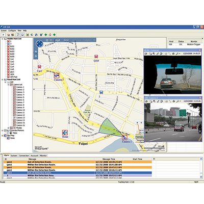
The GV-GIS is a GIS (Geographic Information System) based central management system for GeoVision devices.
The vehicle tracking and remote location verification from the GV-GIS is made possible by the GPS receiver attached to GV-Video Server and GV-Compact DVR to constantly obtain the GPS data (vehicle coordinates and speed) from the satellite, and through mobile internet connection (e.g. UMTS, EV-DO, EDGE, GPRS, GSM, etc) to transmit the GPS data to the GV-GIS.
Besides real-time vehicle tracking, you can also monitor the location of cameras and the status of I/O devices from the DVR and NVR, without GPS functions for city surveillance.